

Tasmania currently faces no active wind warnings, with the Bureau of Meteorology confirming clear advisory status across all regions. The state’s Tasmania forecasts page explicitly indicates “No warnings for Tasmania,” marking a period of relative meteorological calm following recent gusty conditions.
Despite the absence of current alerts, observation stations continue recording variable wind patterns. Maatsuyker Island registered the day’s highest gust at 76 km/h, while elevated areas including kunanyi/Mount Wellington experienced gusts reaching 41 km/h. Coastal monitoring at Cape Bruny tracked winds of 30 km/h.
Temperature differentials across the island remain significant, with Butlers Gorge recording -0.8°C and St Helens reaching 24.1°C. These variations create localized atmospheric pressure gradients that influence regional wind behavior even in the absence of formal warnings.
Is There a Current Wind Warning for Tasmania?
- No active wind warnings currently affect any Tasmanian maritime or terrestrial region.
- Maatsuyker Island recorded the highest recent wind gust at 76 km/h without triggering gale warning protocols.
- Moderate conditions prevail across most populated areas, with sustained winds between 4-17 km/h.
- Historical context shows the most recent gale warning expired on February 10, 2026, for Lower East and South East coasts.
- Temperature extremes today ranged from -0.8°C at Butlers Gorge to 24.1°C at St Helens.
- Continuous monitoring remains operational via the Bureau’s observation network.
| Fact | Details |
|---|---|
| Current Warning Status | No active wind warnings |
| Issuing Authority | Bureau of Meteorology |
| Maximum Recorded Gust (Today) | 76 km/h at Maatsuyker Island |
| Elevated Terrain Gust | 41 km/h at kunanyi/Mount Wellington |
| Coastal Observation | 30 km/h at Cape Bruny |
| General Wind Range | 4-17 km/h across most areas |
| Last Expired Warning | February 10, 2026 (Lower East and South East coasts) |
| State Temperature Range | -0.8°C to 24.1°C |
What Areas in Tasmania Are Affected?
No regions currently fall under wind warning protocols. However, recent observation data identifies specific locations that experienced elevated wind speeds warranting monitoring.
Coastal Monitoring Stations
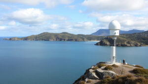
Maritime observation points have recorded the most significant wind activity. Maatsuyker Island, situated off Tasmania’s southern coast, registered 76 km/h gusts. Cape Bruny lighthouse station tracked sustained winds of 30 km/h, representing typical exposed coastal conditions.
Maatsuyker Island recorded 76 km/h winds today, though meteorological thresholds for gale warnings were not met.
Elevated and Inland Zones
Mountainous terrain continues generating localized wind acceleration. The kunanyi/Mount Wellington summit station recorded 41 km/h gusts, demonstrating orographic effects common to Tasmania’s elevated regions. Inland valleys including Butlers Gorge remain sheltered, experiencing minimal wind activity despite the sub-zero temperatures recorded there.
What Wind Speeds Are Expected?
Current meteorological data indicates stable wind patterns across Tasmanian population centers. The Tasmania observations network shows most stations reporting moderate breezes within normal parameters for the season.
Recent Maximum Observations
Isolated peaks have reached 76 km/h at exposed maritime stations, while elevated terrain consistently reports 30-41 km/h gusts. These figures fall below the sustained 63 km/h threshold typically required for gale force classifications.
Warning Threshold Standards
Gale warnings generally trigger when sustained winds reach 63 km/h or gusts exceed 90 km/h. Current observation data shows maximum gusts of 76 km/h at Maatsuyker Island, remaining below formal warning criteria despite representing strong breeze conditions.
Safety Advice and Potential Impacts
While no immediate wind hazards threaten the state, standard precautions apply for the current variable conditions. Historical data from the February 10 advisory provides context for potential future warnings.
Maritime Considerations
Mariners operating near Maatsuyker Island or southern coastal routes should note recent 76 km/h gusts. The Bureau’s warnings page provides real-time marine wind alerts when conditions deteriorate.
The February 10, 2026 gale warning for Lower East and South East coasts expired without extension, though similar patterns may recur with advancing weather systems.
Infrastructure Monitoring
Elevated terrain experiencing 41 km/h gusts requires standard securing of loose materials. The Tasmanian Emergency Services coordinate response protocols when warnings reach severe levels.
Weather stations continuously monitor for sustained winds exceeding 63 km/h that would trigger new gale warnings for coastal communities.
Wind Warning Timeline and Recent Events
-
Gale warning issued for Lower East and South East coasts. Source: Meteorology Bureau archives
-
Coastal advisory expired; no extensions issued for subsequent periods.
-
Maatsuyker Island records 76 km/h gust without triggering new warning protocols. Source: BOM Places Tasmania
-
Bureau confirms “No warnings for Tasmania” across all forecasting districts.
Warning Certainty and Information Status
| Verified Information | Uncertain or Pending |
|---|---|
| No active wind warnings currently exist | Timing of next potential advisory |
| Maatsuyker Island recorded 76 km/h gust today | Duration of current calm conditions |
| February 10 warning expired without renewal | Intensity of approaching weather systems |
| Most areas experience 4-17 km/h winds | Specific timing of warning reactivation |
| Temperature range: -0.8°C to 24.1°C | Geographic scope of future warnings |
Weather Patterns and Historical Context
Tasmania’s position within the Roaring Forties latitude subjects the island to persistent westerly airflow, though current patterns show reduced intensity. The 76 km/h gust at Maatsuyker Island represents typical exposure for the island’s southern maritime boundary rather than anomalous severe weather.
Historical data indicates February 10 marked the most recent significant advisory, affecting specifically the Lower East and South East coasts. The absence of subsequent warnings suggests stable high-pressure influence over the region.
Temperature differentials between Butlers Gorge and St Helens illustrate the state’s microclimatic diversity, with inland frost conditions contrasting sharply with coastal warmth. These gradients generate localized wind phenomena distinct from broader synoptic warnings.
Official Sources and Meteorological Data
Primary meteorological intelligence derives from the Bureau of Meteorology’s Tasmanian observation network. Real-time data streams from Maatsuyker Island, kunanyi/Mount Wellington, and Cape Bruny inform current assessments.
No warnings for Tasmania.
— Bureau of Meteorology Tasmanian Forecasts
Secondary verification comes from ABC News Weather services and historical warning archives maintained by meteorological databases.
Summary and Monitoring Guidance
Tasmania maintains clear warning status with no active wind alerts, though recent gusts of 76 km/h at Maatsuyker Island demonstrate continued need for observation. Residents and mariners should monitor Tasmania forecasts for real-time updates as atmospheric conditions evolve.
Frequently Asked Questions
Is the Tasmania wind warning still active?
No. The Bureau of Meteorology confirms no current wind warnings affect Tasmania. The last gale warning expired on February 10, 2026.
How long will the Tasmania wind warning last?
No warning is currently in effect. Future warnings depend on meteorological developments and will be issued when sustained winds reach 63 km/h or gusts exceed 90 km/h.
Which parts of Tasmania have gale force winds?
No regions currently experience gale force winds. Recent gusts reached 76 km/h at Maatsuyker Island and 41 km/h at Mount Wellington, remaining below gale thresholds.
What areas in Tasmania are affected by wind warnings?
Currently no areas are affected. The February 10 warning previously impacted Lower East and South East coasts, but this has expired.
Where can I find the BOM Tasmania wind warning map?
Official warning maps and interactive radar are available through the Bureau of Meteorology’s Tasmanian warnings page and forecasts portal.
What are the impacts of Tasmania wind warnings?
When active, warnings indicate potential for damaging winds, affecting maritime operations, coastal infrastructure, and elevated terrain. Current conditions present no such impacts.
Related stories


Liam O'Brien covers Australian politics and public affairs for Coast Current.